Tarutao Gr
Period:
Cambrian, Ordovician
Age Interval:
Upper Cambrian-Lowermost Ordovician (3)
Province:
Sibumasu: Lower Peninsula
Type Locality and Naming
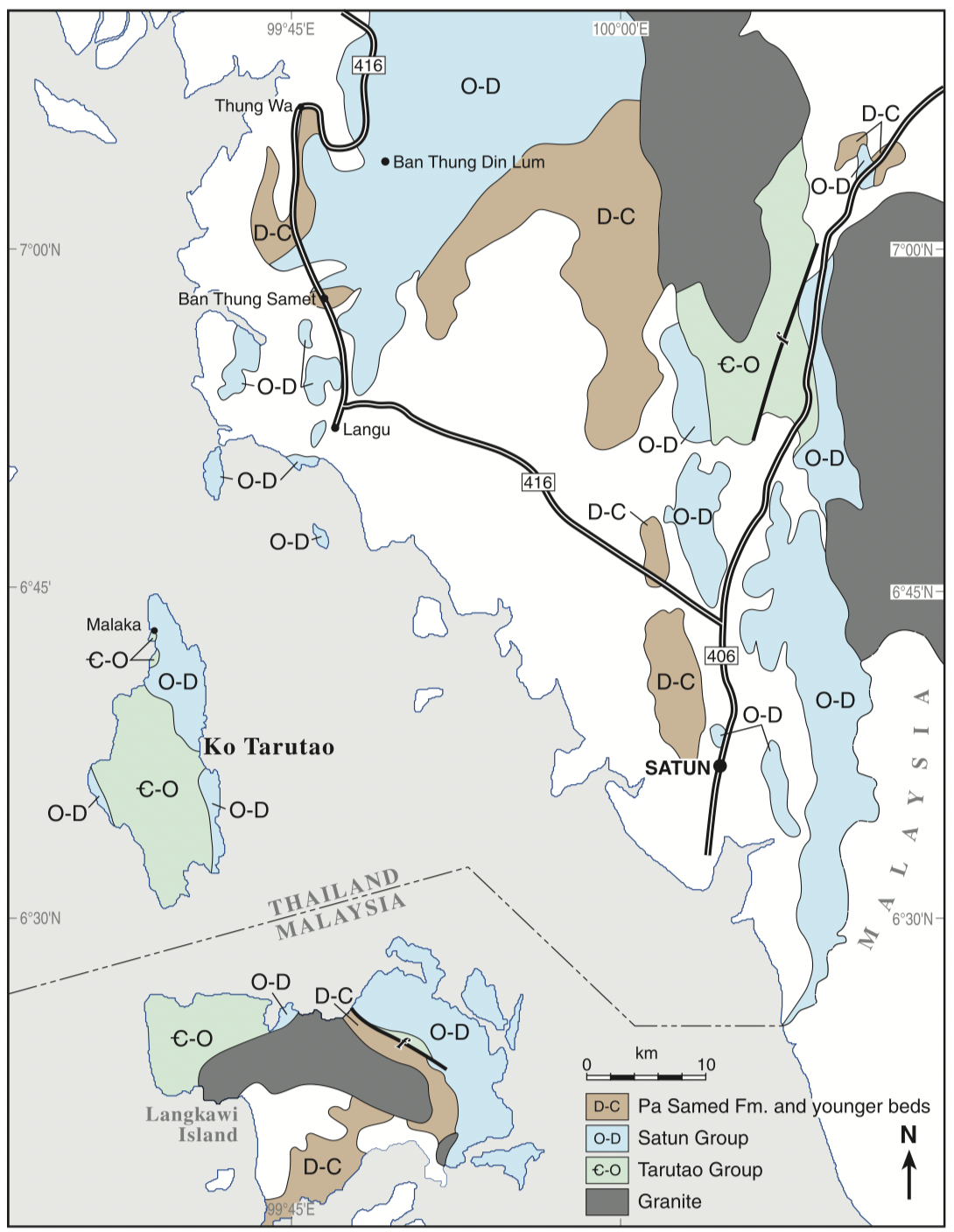
At Ao Talo Topo, extending, from Laem Hin Ngam (grid.360 682) to the limestone point (grid 375 709) in the L 7017 series, map no 4922 III by Javanaphet (1969). The best exposures on the mainland examined by Ridd (2011) are beside Highway 41 and in railway cuttings between 8 and 12 km east of Thung Song.
[Figure: Sketch geological map (from various sources) of the southern part of Peninsular Thailand and Langkawi Island of Malaysia. Note that Thai stratigraphic nomenclature has been extended to Langkawi Island (Ridd. 2011)]
Synonym: กลุม่หินตะรุเตา
Lithology and Thickness
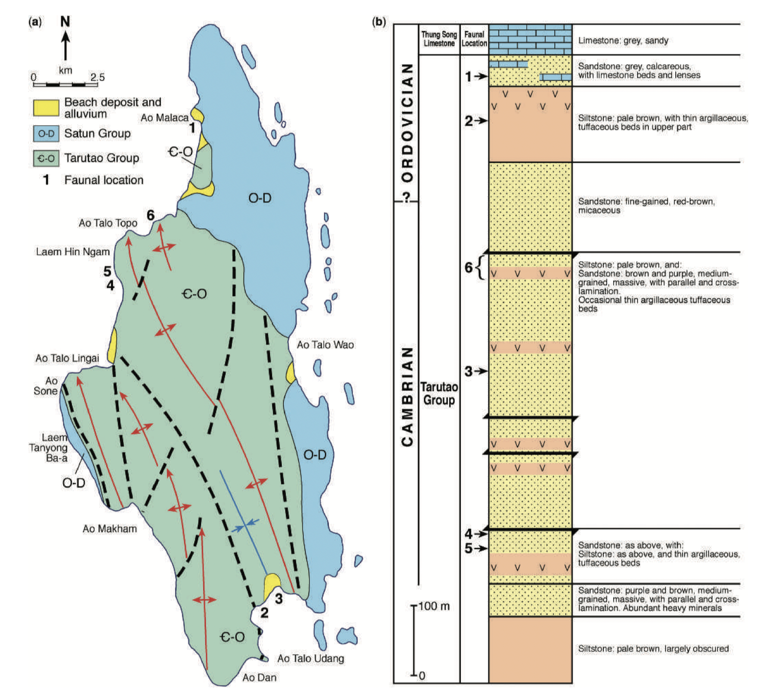
Quartzose and variegated sandstone, thinly to thickly bedded, poorly developed tabular cross beds. Remarks: The Tarutao Group was first mentioned by Javanaphet, 1969. This description was taken from the Tarutao formation (Bunopas, 1981). The Tarutao "formation" is obsolete. Constituent formations need to be published for this group (Lexicon of Stratigraphic Names of Thailand, 2013). At type locality, Ridd (2011) summarizes 3 units: Lower unit (490 m) = coarsening-upward succession of alternating graded siltstones, mudstones and argillaceous sandstones. Middle unit (1950 m) = mainly sandstone with some acidic tuffs Upper unit (575 m) = Fining-upwards sequence of very fine-grained sandstone, siltstone and tuffaceous mudstone with minor limestone intercalations. Estimates total Thickness: 3,000 m (Ridd, 2011 type section); 1,000 m (Bunopas, 1981); 850 m (Tansuwan and others, 1982)
[Figure: (a) Geological map of Ko Tarutao and (b) composite section of the Cambrian to Ordovician Tarutao Group on the island (modified from Shergold et al. 1988). Heavy lines on the stratigraphic column represent faults, although information is lacking on their sense of throw. (Ridd. 2011)]
Lithology Pattern:
Sandstone
Relationships and Distribution
Lower contact
Khanom Gneissic Complex Gr (unconformable)
Regional extent
Lower peninsular. Correlation: Phuket series Fm (Brown and others, 1951), Machinchang Fm in Malaysia.
GeoJSON
{"type":"Feature","geometry":{"type":"MultiPolygon","coordinates":[[[[99.37,9.2],[99.66,9.37],[99.89,9.32],[100.16,8.78],[100.39,7.93],[100.58,6.98],[100.57,6.39],[100.32,6.3],[99.81,6.7],[99.24,7.45],[98.82,8.18],[99.08,8.51],[99.37,9.2]]]]}}
Fossils
Quote from Ridd (2011): "Cocks et al. (2005) have reviewed the faunas collected on Ko Tarutao by themselves and earlier workers. They note that, within the Uppermost part of the succession, Teraoka et al. (1982) found conodonts of late Tremadoc age and that the Tremadoc trilobites Pseudokainella, Asaphellus, Geragnostus and ?Rossaspis were collected by Stait et al. (1984) at about the same level. At about the middle of the section Cocks et al. (2005) note the late Cambrian trilobites ?Prosaukia, ?Hoytaspis, Lichengia, Lophosaukia, Quadraticephalus, Parakoldinoidea and Tsinania. On the basis of these faunas, the Cambrian–Ordovician boundary lies somewhere within the upper part of the Tarutao Group.
Age
upper-Middle Cambrian-Lowermost Ordovician (Ridd, 2011; Fig. 3.3)
Age Span:
Beginning stage:
Drumian
Fraction up in beginning stage:
0
Beginning date (Ma):
504.50
Ending stage:
Tremadocian
Fraction up in the ending stage:
0.5
Ending date (Ma):
481.55
Depositional setting
Shallow marine, barrier beach complex. Lower unit of Ridd (2011) at type section is interpreted as offshore shelf deposit affected by occasional storms; Middle unit is barrier beach upper shoreface; Upper unit is interpreted as a lagoonal deposit.
Depositional pattern:
Additional Information
Compiler:
Wen Du - modified from Ridd. M. F., 2011, Chapte r3 Lower Palaeozoic in: Ridd, M.F., Barber, A.J., and Grow, M.J., editors, The Geology of Thailand, Geol. Soc. of London.
Lexicon of Stratigraphic Names of Thailand of 2013.
Lexicon of Stratigraphic Names of Thailand of 2013.

